Community Corner
The Days of a Town Center, Two-Lane Roads and Dairy Farms in 'Percipany'
Developmental boom and the construction of major highways changed the town's landscape.


Where is Parsippany?
When people ask me where I live, and I say Parsippany, they ask, “But where...Lake Parsippany?” After this happened a number of times, I realized that most of the historic town of Parsippany is not visible as a town.
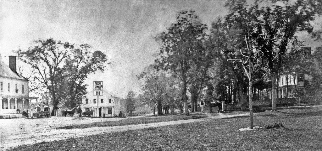
If you had come to Parsippany in the 1940s, you would have seen a different streetscape, one with an actual town center. Cobb’s Corner, at the intersection of routes 46 and 202, had a building on each corner, plus the Parsippany Methodist Church, the old orphanage and the old schoolhouse.
Find out what's happening in Parsippanywith free, real-time updates from Patch.
Single-family homes lined Littleton Road and Parsippany Boulevard. This was a Parsippany of two-lane roads and dairy farms—the development boom of the 1960s and '70s had not begun.
The development of the Jersey City reservoir “drowned” part of Parsippany, the completion of interstates 80 and 287 removed more houses and changed the geography and the placement of old roads. The development of Hills of Troy removed entire hills that used to be in that area.
Find out what's happening in Parsippanywith free, real-time updates from Patch.
The present Town Hall faces I-287, because the former road to Boonton ran in front of the building. The site of the mansion that was the Morris County Children’s Home is now occupied by an office building.
The Parsippany Methodist Church site is under I-287, which also took most of the houses on Littleton Road. The apartment development boom of the 1960s also replaced most houses with rental complexes in the area.
The Presbyterian Church and Vail Cemetery, Righter House and the other small houses on Route 46, and the Livingston Benedict House off Parsippany Road, are all that remain in 2011 of the historic hamlet of Parsippany. The area around the church is now termed “Percipany State Historic District” as a reminder of the town that once existed.
Parsippanong, the Lenape name for Parsippany, meant “place where the brook breathes through the valley.” Percipany, the archaic spelling of the word, appears on colonial maps.
Parsippany-Troy Hills Township was created in 1928, when Parsippany, Troy, Littleton, Mount Tabor, Lake Hiawatha and Lake Parsippany voted to separate from Hanover Township.
The larger township was composed of many small population centers, each settled by a different group of people and each with its own distinctive quality.


